
Mountains have long held a kind of magic over many of us, both enthralled and appalled by their wild irregularity and the glimpse of danger deep in their embrace. Many peaks have great significance to different faiths and cultures, a rich folklore to explain their origin, or are places of pilgrimage for locals and visitors alike.
You are not in the mountains. The mountains are in you.
John Muir
The most spectacular mountains in the world have captivated the imagination of those that have laid eyes on them. The endless play of light and weather creates views that melt and shift in moments. Dynamic landscapes that are at once intimate and vastly unknowable. Peaks that rake the sky and alter the perspective of those that attain the lofty heights. There is no getting accustomed to them.
To aim for the highest point is not the only way to climb a mountain.
Nan Shepherd, The Living Mountain
Whether you’re a seasoned mountaineer, passionate orographer or geologist, a photographer, or merely an inquiring traveller, there’s going to be a mountain on this list that will leave you spellbound.
Stetind
- Coordinates: 68°09’54” N 006°35’34” E
- Location: Nordland, Norway
- Elevation: 1,392 metres (4,566′)

This is Norway’s national mountain; its sheer granite walls soaring over Tysfjord to the distinctive summit, once described as the anvil of the Gods. Fishermen in the Lofoten Islands used its characteristic profile as a navigation mark. Pioneering British explorer and mountaineer William Cecil Slingsby called it the ugliest mountain he ever saw, though he may have been bitter after failing in his attempt to make the summit. I think we’d have to disagree.
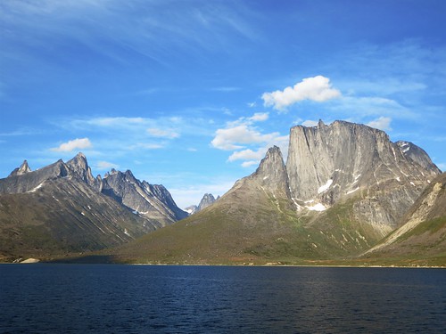
Thor Peak
- Coordinates: 66°32’00” N 065°19’00” W
- Location: Baffin Island, Nunavut, Canada
- Elevation: 1,675 metres (5,495′)
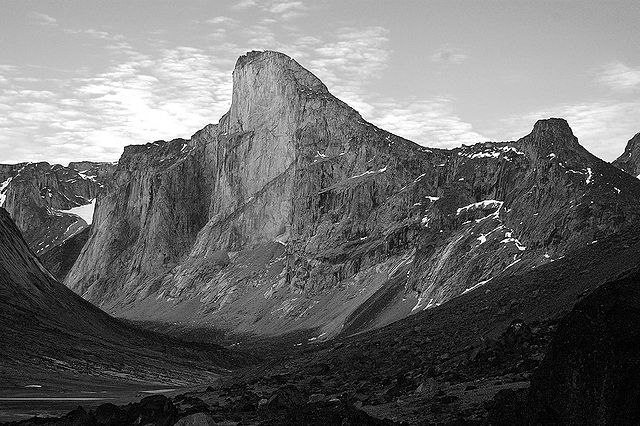
Thor Peak, in Auyuittuq National Park on remote Baffin Island, a towering wave of granite rising up from the Akshayuk Valley, is the location of the greatest vertical drop in the world, a staggering 1,250 metres (4,101′) high*. To put that into context, the Empire State Building is just 443 metres high and the Burj Khalifa, the tallest human-built structure in the world, is 830 metres high. Auyuittuq is an Inuktitut word meaning “land that never melts”. White knuckles and frozen fingertips guaranteed.
*It would take a spine-chilling 36 seconds for someone weighing 80kg to fall the 1,250m from the face below the summit all the way to the valley floor.
Snæfellsjökull
- Coordinates: 64°48’21” N 023°46’23” W
- Location: Snæfellnes, Iceland
- Elevation: 1,446 metres (4,744′)

This 700,000-year-old cone-shaped stratovolcano at the western tip of the Snæfellsnes peninsula inspired the adventure in Jules Verne’s novel Journey to the Centre of the Earth. Largely dormant since around 200 CE, Snæfellsjökull had long been topped by a compact glacier, indeed the name translates to “snow mountain glacier”. However, rising temperatures in the region mean that the summit crater has been ice-free since 2012. In clear conditions, it can sometimes be seen from Reykjavik, 120km away across Faxa Bay, and it was the last sighting I had of Iceland as I sailed into the west on the Viking ship Draken Harald Hårfagre.
Denali
- Coordinates: 63°04’10” N 151°00’27” W
- Location: Alaska, USA
- Elevation: 6,201 metres (20,343′)

Denali means “The Great One” in the Athabaskan language, but this wasn’t the official name of this colossal massif until 2015. For most of its modern history, it was known as Mount McKinley, named for US President William McKinley. In mountaineering circles, it also goes by the nickname “Mount Mid-Life Crisis”, as one of the more accessible of the Seven Summits, however, it is reputed to be especially challenging due to unpredictable weather and extreme elevation from sea level. For those less inclined to bag the summit, spectacular views can be found along the Parks Highway (Alaska Route 3), and from Denali National Park and Preserve.
Ketil
- Coordinates: 60°24’59” N 044°30’44” W
- Location: Kujallaq, Greenland
- Elevation: 2,010 metres (6,594′)
Ketil is just one of the sky-high granite peaks lining the arrestingly beautiful Tasermuit Fjord in southern Greenland. Known as Uiluit Qaqqaa in Greenlandic, meaning “oyster shell mountain”, its common name harks back to one of the Norse settlers that arrived in Greenland under the leadership of the notorious Erik the Red. The west face of Ketil is one of the world’s biggest and most challenging near-vertical big wall climbs, soaring over 1,000 metres. Despite being well off the beaten track, it’s becoming increasingly popular with climbers in recent years.
Suilven
- Coordinates: 58°06′54″ N 005°08′13″ W
- Location: Assynt, Scotland
- Elevation: 731 metres (2,398′)
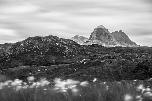
Suilven, or Sùilebheinn in Scots Gaelic, is diminutive in comparison to most of the others on this list, but in my opinion, it’s the most beautiful of them all. An inselberg with an iconic profile, it’s a steep-sided ridge carved by ancient glacial ice rising over a wilderness area of bogs, lochans, and rough moorland. From the highest point, known as Caisteal Liath (Grey Castle), the sheer sides reminiscent of the rocky ramparts of an impenetrable fortress, the panoramic views of Sutherland and the Hebrides are outstanding.
Read: A Beginner’s Guide to the Scottish Munros
The Eiger
- Coordinates: 46°39′39″ N 008°00′19″ E
- Location: Bernese Alps, Switzerland
- Elevation: 3,967 m (13,015 ft)

The Eiger is a mountain with fearsome beauty and a notorious reputation. The technically challenging North Face, first ascended in 1938 by a German-Austrian expedition, is one of the most deadly; at least sixty-four climbers are known to have perished on the face, earning it the epithet Mordwand, the “murder wall”. In 2015 legendary speed climber Ueli Steck scaled the Heckmair route up the North Face in an astonishing 2 hours 22 minutes and 50 seconds. For those less inclined to risk life and limb, mountain views can be glimpsed from the route of the Jungfraujoch railway or the après ski terraces of Kleine Scheidegg.
Tre Cime di Lavaredo
- Coordinates: 46°37′07″ N 018°20′00″ E
- Location: Dolomites, Italy
- Elevation: 2,999 metres (9,839′)
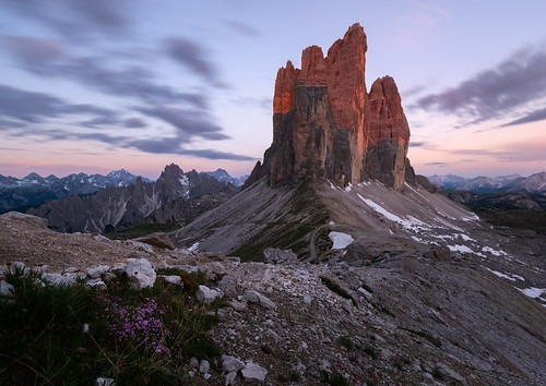
In the Italian province of South Tyrol / Südtirol, the rugged Tre Cime di Lavaredo, also known as Drei Zinnen, as the name suggests, are three distinct peaks that make one of the most iconic views in the Dolomites. A 10km circular hike from Rifugio Aurenzo is one of the finest day hikes in the area, taking in spectacular views of the peaks, picturesque mountain lakes, and remains of trenches and tunnels from when the region was part of the Alpine front during WWI. It’s the ideal location to try your hand at Via Ferrata, and gain a new perspective in the mountains.
Matterhorn
- Coordinates: 45°58′35″ N 007°39′31″ E
- Location: Pennine Alps, Switzerland and Italy
- Elevation: 4,478 metres (14,694′)
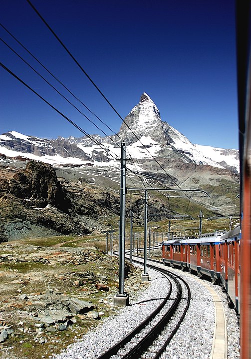
One of the highest summits in the Alps, the near symmetry of the Matterhorn has enchanted visitors to the region since the advent of Alpine tourism in the mid-19th century. The iconic pyramidal peak was first summited by mountain pioneer Edward Whymper in 1865, though not without tragedy, and it now attracts hundreds of climbers attempting an ascent every year. Visitors to Zermatt can get closer to the mountain without climbing on the Gornergatt mountain railway, or gondola lift to the Kleine Matterhorn station.
Aiguille du Dru
- Coordinates: 45°55′58″ N 006°57′23″ E
- Location: Alps, France
- Elevation: 3,754 metres (12,316′)
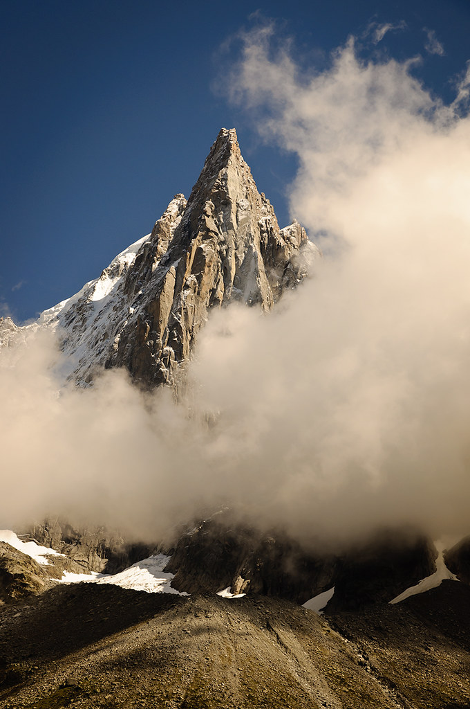
Appropriately, aiguille translates from French as needle, a fitting name for the arresting granite spire of Aiguille du Dru, in the Mont Blanc massif. The highest summit is known as Grand Dru, though it is a sub-summit, Petit Dru at 3,733 metres, that is considered one of the six greatest north face walls of the Alps. Many of the routes pioneered up the wall have been lost in rockfalls over the years considerably altering the profile of the peak.
Half Dome
- Coordinates: 37°44′46″ N 119°31′59″ W
- Location: Sierra Nevada, California, USA
- Elevation: 1,444 metres (4,737′)
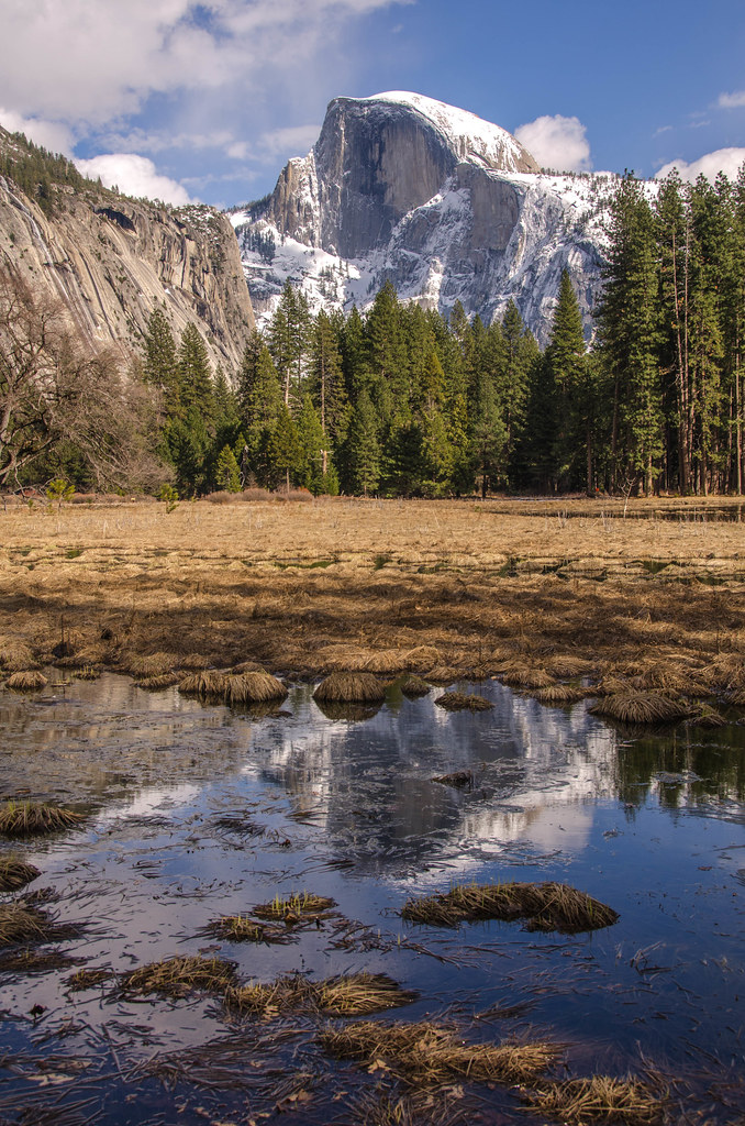
The iconic outline of Half Dome, towering over the eastern end of the Yosemite Valley, was made famous by legendary American photographer Ansel Adams in his striking black and white landscape images. The first technical ascent of the sheer northwest face took place over five days in 1957; the same route was completed free solo in a remarkable 1 hour 22 minutes by Alex Honnold in 2012 (see the documentary Alone on the Wall). Hikers can reach the summit of Half Dome on the Cable Route between May and October, though a permit is required from the Yosemite National Park Authority and it can be crowded on a summer weekend.
Trango Towers
- Coordinates: 35°46′00″ N 076°10′59″ E
- Location: Baltoro Muztagh, Karakoram, Pakistan
- Elevation: 6,286 metres (20,623′)
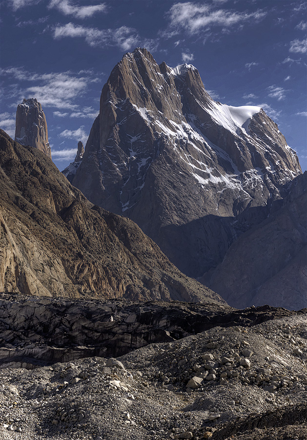
The Trango Towers are a series of soaring granite pinnacles in the Baltoro Muztagh, northern Pakistan, not far from K2 and the Gasherbrum peaks. The Towers feature some of the most immense sheer walls in the world, with the east face of Trango Tower claiming the title of the greatest near-vertical drop on earth at 1,340m. The region only opened to outsiders in 1975, allowing the discovery of some of the most challenging climbs ever completed, a combination of altitude, steepness, and the technical nature of the big walls.
Fujiyama (Mount Fuji)
- Coordinates: 35°21′29″ N 138°43′52″ E
- Location: Honshū, Japan
- Elevation: 3,776 metres (12,388′)
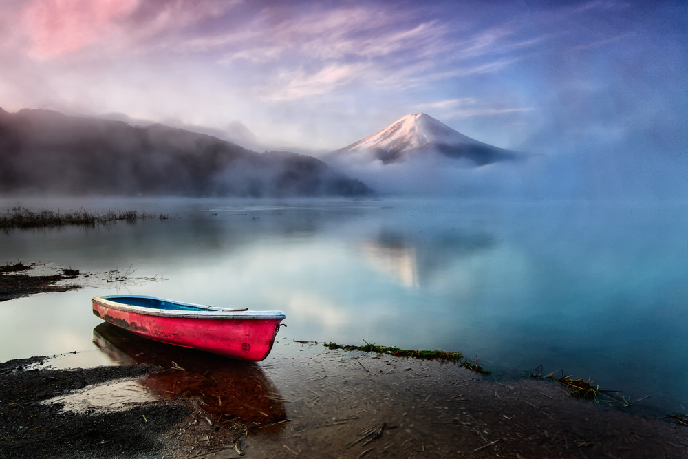
There is a saying in Japanese; He who climbs Fuji is a wise man, he who climbs it twice is a fool. Fujiyama is a captivating volcanic cone, capped with snow for almost half the year, that has enthralled and inspired artists through the ages. Almost 300,000 visitors troop to the summit annually, so the tranquillity of the peak is best appreciated from afar. The mirror lake of Kawaguchiko (Lake Kawaguchi) and the Edo-era buildings at the Iyashi-no-Sato open-air museum on Saiko (Lake Sai) offer the finest viewpoints.
Read: Why Mountains Matter on International Mountain Day
Machapuchare
- Coordinates: 28°29′42″ N 083°56′57″ E
- Location: Anapurna Massif, Nepal
- Elevation: 6,993 metres (22,943′)

Machapuchare is named for the notched summit ridge and double peaks, reminiscent of a fishtail when viewed from the Annapurna sanctuary. The mountain is sacred to the Hindu religion, believed to be one of the earthly homes of the god Shiva. It’s long been claimed that no human has ever set foot on the summit; in 1957 an expedition led by British climber Wilfred Noyce reached within 150m (492′) of the summit before turning back. No climbing permits have been issued since. It’s rumoured that New Zealand climber Bill Denz made an illegal ascent in the 1980s, though he perished on nearby Mansulu in an avalanche in 1983, taking the truth with him.
Ama Dablam
- Coordinates: 27°51′40″ N 086°51′40″ E
- Location: Eastern Himalayas, Nepal
- Elevation: 6,812 metres (22,349′)
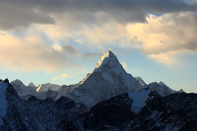
With a name meaning “Mother’s necklace”, the arresting Ama Dablam appears to reach out in an embrace as two ridges reach out from either side of the main peak. It lies close to the route of the popular trek to Everest Base Camp, towering over Thyangboche Tibetan Monastery (also known as Dawa Choling Gompa), once home to Tensing Norgay before his mountaineering career took off, and often captures the hearts of those that pass by, enticing them to return.
Cotopaxi
- Coordinates: 00°40′50″ S 078°26′16″ W
- Location: Andes, Ecuador
- Elevation: 5,897 metres (19,347′)
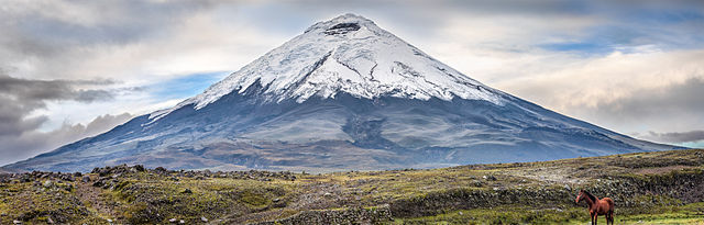
A stunning stratovolcano with a distinctive snow-capped cinder cone, Cotopaxi is the second-highest peak in Ecuador and can be seen on the skyline from Quito and while driving the Panamerican Highway. It’s also one of the most active volcanoes on this list, with 87 recorded eruptions since 1534, the most recent in 2015-16. The mountain and surrounding National Park eventually re-opened to visitors in late 2017, and with time for acclimatisation, the summit can be gained on a challenging but non-technical ascent.
Kilimanjaro
- Coordinates: 04°03′33″ S 037°21′12″ E
- Location: Kilimanjaro region, Tanzania
- Elevation: 5,895 metres (19,308′)
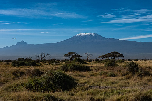
Kilimanjaro does not, in fact, rise like Olympus over the Serengeti; instead, the world’s highest freestanding mountain soars above the savannah of Tsavo and Amboseli, on the Kenyan side of the border. As one of the Seven Summits, it features on the to-do list of most mountaineers, but scaling the peak needs no technical skill and large numbers of people attempt the trek to the summit. Trails lead through a succession of ecozones with distinct flora and fauna, before emerging onto a rocky lunar world and the glaciated landscape of the summit.
Mount Roraima / Monte Roraima
- Coordinates: 05°08′36″ N 060°45′45″ W
- Location: Pakaraima Mounains / Sierra Pacaraima, Guyana, Brazil and Venezuela
- Elevation: 2,810 metres (9,220′)
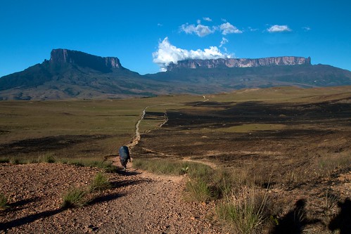
Spectacular Mount Roraima is the highest tepui, or table-top, in the Guiana Highlands of South America, a vast plateau bounded on all sides by 400 metre (1,300′) high cliffs. The national borders of Brazil, Venezuela, and Guyana meet at a tripoint on the top, which was unexplored until 1884. The mysterious plateau is home to a unique diversity of flora and fauna, and often seen shrouded in mists, inspiring both the setting of Paradise Falls in the Pixar film Up, and the living dinosaur haven in Arthur Conan Doyle’s novel The Lost World.
Alpamayo
- Coordinates: 08°54′45″ S 077°39′07″ W
- Location: Cordillera Blanca, Peru
- Elevation: 5,947 metres (19, 511′)

Alpamayo is often named the most beautiful mountain in the world, and the near-perfect pyramid of ice and rock in the Peruvian Cordillera Blanca is certainly hard to resist. Not even surveyed until the 1940s, due to its remote location, it was successfully summited first by a German expedition in 1957. The steep faces of Vienetta-like fluted ice require a high level of technical ice climbing ability, but superb views of the peak can be taken from the trek to basecamp, or the multi-day Alpamayo circuit route.
Huayna Picchu
- Coordinates: 13°09′27″ S 072°32′50″ W
- Location: Andes, Peru
- Elevation: 2,693 metres (8,835′)
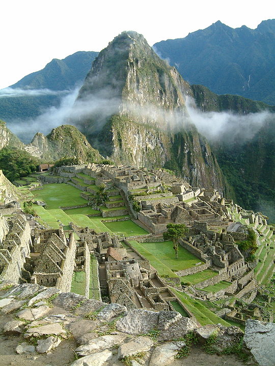
Huayna Picchu is the iconic sugarloaf peak that looms over the Inca citadel of Machu Picchu, forming the backdrop of the view from Inti Punku (the Sun Gate) and the final section of the Inca Trail route. Trekkers can follow a waymarked trail to the summit, with sections of scrambling with cable and railings for support, for a vertiginous perspective on the ancient city, named as one of the Seven New Wonders of the World.
Pic d’Imarivolanitra (Pic Boby)
- Coordinates: 22°11′42″ S 046°53′06″ E
- Location: Andringita Massif, Madagascar
- Elevation: 2,658 metres (8,720′)
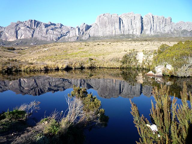
Madagascar might be better known for its unique wildlife, but the sheer granite walls of the Andringita Massif often draw the comparison with the more well-known peaks of Yosemite, and have been a pull for big wall climbers since the 1990s. The towering presence of Pic d’Imarivolanitra, also known as Pic Boby, is Madagascar’s second-highest mountain, and a feature of trekking circuits through Andringita National Park and nearby Tsarnovo Valley. At around 2,000 metres (6,5652′) high the trails pass through a dreamlike landscape of rock gardens filled with colourful succulents, before descending into lush forest.
Table Mountain
- Coordinates: 33°57′26″ S 018°24′11″ E
- Location: Cape Province, South Africa
- Elevation: 1,085 metres (3,559′)
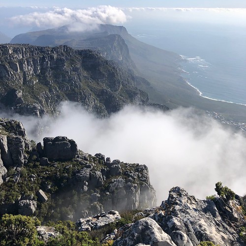
The stark profile of Table Mountain dominates the skyline of Cape Town, despite its relative lack of stature. While this entry on the list offers an easy route to the top via the Aerial Cableway, there are several hiking routes of varying difficulty that lead up the mountain and across the vast summit plateau, including through the beautiful Kirstenbosch National Botanical Gardens and out to the shark fin of Devil’s Peak. The mountain is home to unique native vegetation, part of the designated Cape Floristic Region World Heritage Site.
Cradle Mountain
- Coordinates: 41°40′48″ S 145°56′24″ E
- Location: Central Highlands, Tasmania, Australia
- Elevation: 1,545 metres (5,069′)

At the heart of the Tasmanian Wilderness World Heritage Area, the rugged basalt peaks of Cradle Mountain rise over lakes carved out by ancient glaciers surrounded by alpine moorland and temperate rainforest. The area is home to unique Australian wildlife with absurd names; echidnas, wombats, quolls, pademelons, and the elusive Tasmanian Devil. There’s a darker history to the region too; following violent persecution by European settlers, the last free Aboriginal Tasmanians were sighted in the area in 1836. The Overland Track, an iconic bushwalking trail considered one of the world’s best, links Cradle Mountain to Lake St. Clair, the deepest in Australia.
Monte Fitz Roy / Cerro Chaltén
- Coordinates: 49°16′16″ S 072°02′35″ W
- Location: Andes, Patagonia, Argentina and Chile
- Elevation: 3,405 metres (11,171′)
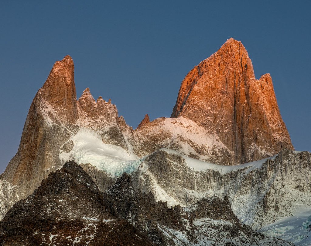
Named Fitz Roy in honour of Robert Fitz Roy, captain of HMS Beagle, who charted large stretches of the Patagonian coastline, this imposing shark-tooth peak sits astride the international border between Argentina and Chile. First ascended in 1952, the peak has drawn the attention of several notable climbers, including Tommy Caldwell (The Dawn Wall) and Alex Honnold (Free Solo), who traversed the 5km long ridgeline of Fitz Roy and its satellite peaks. For those less inclined to scale lofty heights, the peak is the spectacular backdrop to several trekking routes in Parque Nacional Los Glaciares and day hikes around the village of El Chaltén. The routes lead through woodlands and montane meadows, to reach spectacular glacial lakes and rugged boulder fields.
Cerro Torre
- Coordinates: 49°17′34″ S 073°05′54″ W
- Location: Andes, Patagonia, Argentina and Chile
- Elevation: 3,128 metres (10,262′)
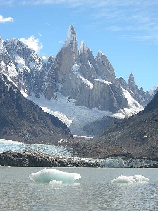
Another peak often touted as the most beautiful in the world, Cerro Torre is an arresting pinnacle of granite topped with an otherworldly mushroom of rime ice. Its undeniable beauty is matched only by its colourful history. Declared an impossible summit by climbing pioneer Walter Bonetti, the Italian climber Cesare Maestri claimed success in 1959. His partner Toni Egger was swept away in an avalanche on the descent, taking with him the only camera recording the event. Further attempts using a variety of climbing techniques only brought more controversy and claims of desecrating the singular nature of the peak. A story worth delving into further for mountain buffs.
Ulvetanna Peak
- Coordinates: 71°50′60″ S 008°19′59″ W
- Location: Drygalski Mountains, Queen Maud Land, Antarctica
- Elevation: 2,930 metres (9,612′)
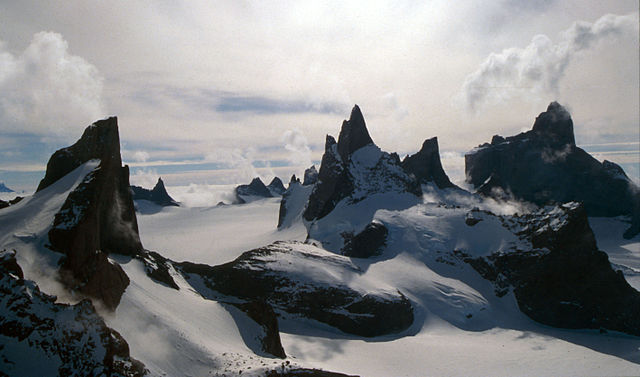
The granite peak of Ulvetanna, meaning “the wolf’s tooth” in Norwegian, is one of the most inaccessible mountains in the world. A captivating spire of rock in the Fenriskjeften Mountain, it rises like a fairytale castle over the white expanse of the ice sheet below. It was first climbed in 1994, but its remote location means it’s unlikely to make it on to your mountain bucket list unless you’re an experienced mountaineer with polar connections. Instead, you can vicariously explore it from the comfort of your home by watching The Last Great Climb, documenting the first ascent of the northeast ridge by British climber Leo Houlding and his team.
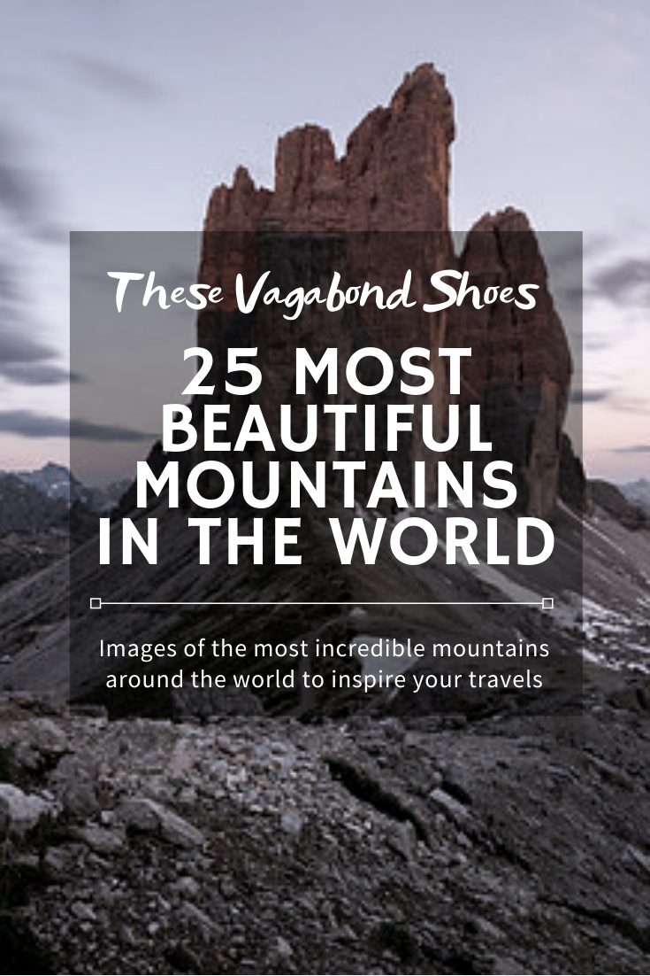
The 25 Most Beautiful Mountains in the World
Why not save this dose of mountain inspiration for later?

2 thoughts on “The 25 most beautiful mountains in the world”